
Remembering a unique railway – the Weston, Clevedon & Portishead.
We are the only group dedicated solely to this railway.


Copyright © 2009-2026 WC&P Railway Group

|
Maps: Alan Godfrey Old Ordnance Survey |
|
|
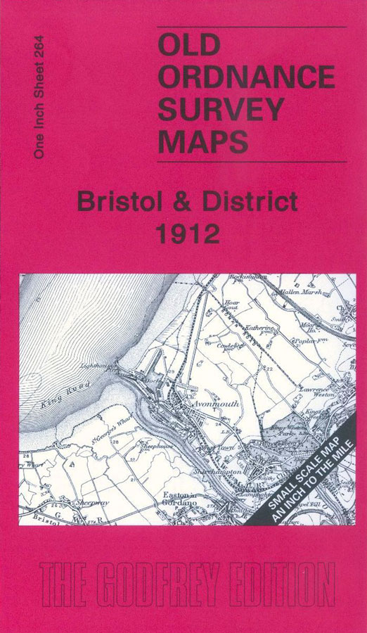
One Inch Sheet 264 - Bristol & District 1912 This One Inch to the Mile map covers the Bristol area, with coverage stretching from Clevedon eastward to Keynsham and Kingswood, and from Stoke Gifford southward to Chew Magna. The City of Bristol is, of course, the dominant feature but the map also shows the coastal towns of Clevedon, Portishead and Avonmouth, with the various railways linking them with the area. The WC&PR is shown running from Portishead to the River Banwell just before present day Worle. On the reverse is included a map of the village of Nailsea. Other towns and villages included: Gloucestershire: Avonmouth, Bristol, Clifton, Filton, Frenchay, Henbury, Kingswood, Shirehampton, Stoke Gifford, Winterbourne. Somerset: Abbots Leigh, Backwell, Barrow Gurney, Bedminster, Bishopsworth, Brislington, Brockley, Chew Magna, Clapton in Gordano, Clevedon, Compton Dando, Congresbury, Dundry, Easton in Gordano, Flax Bourton, Kenn, Keynsham, Kingston Seymour, Long Ashton, Nailsea, Norton Malreward, Pill, Portbury, Portishead, Publow, Puxton, Queen Charlton, Stanton Drew, Tickenham, Walton-in-Gordano, Weston in Gordano, Whitchurch, Winford, Wraxall, Wrington, Yatton. Price is £3 plus postage & packing CODE: MAP264 (RRP is £3.50) |
|

Map: Bristol & District 1912

£3.00